
The Battle of the Bulge, a decisive confrontation in World War II, unfurled amidst the wintry woodlands and undulating hills of the Ardennes region, like a tapestry woven with threads of valor, treachery, and formidable strategic maneuvering. This monumental clash, which began in December 1944 and continued into January 1945, served as the last grand offensive by Nazi Germany on the Western Front. Here lies an exploration of the intricate maps that document this significant engagement—artifacts of strategy, conviction, and the indomitable human spirit.
Maps serve as more than mere representations of terrain; they are cartographic narratives imbued with the essence of battles fought and lives sacrificed. In the context of the Battle of the Bulge, these maps are akin to a scheming mind’s blueprint, illustrating not only the geography but also the implications behind movements made by military leaders. Understanding this confrontation begins with an examination of the topography itself—an enigma wrapped in ice, shrouded in fog.
The Ardennes, characterized by dense forests and rolling hills, presented a formidable obstacle. Picture a rugged canvas painted with shades of green and white; the forested expanse obscured visibility while simultaneously offering discrete pathways for unseen advances. The German high command, aware of the Allies’ waning vigilance, devised a plan that felt almost mystical—an unexpected thrust through the Ardennes, leveraging the element of surprise like a magician conjuring an illusion from thin air.
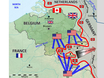
Maps detailing troop placements—German and Allied alike—within this hallowed ground reveal much about the audacity of the German counteroffensive. The initial German invasion force comprised roughly 250,000 troops, divided into strongholds that stretched across a flailing front. Each unit marked on the map is a testament to the meticulous planning that fueled this operation, as well as to the cunning tactics employed to confuse enemy eyes intent on discerning the true threat looming over the Allied line.
At the very heart of this confrontation lay the town of Bastogne, a strategic nexus that acted as the keystone in the Allies’ defensive arch. As frost blanketed the region, maps became the lifeblood of strategic conversations; they depicted Bastogne as a pivotal bastion, a microcosm of wider objectives. Picture a chessboard where each move could shift fortunes—Bastogne was the queen, commanding immense power. Its defense was crucial. When German forces encircled the town, maps transformed into a canvas for exuberance and desperation alike.
The plight of the 101st Airborne Division in Bastogne is legendary; their tenacity amidst encroaching darkness mirrored the spirit of the intrinsic map itself—where contingency plans, supply lines, and reinforcements danced between ink and fate. The artillery units stationed on the outskirts, as depicted on these maps, were not mere symbols but rather promises of resounding support, their barrages reverberating like echoes from an unseen hero, instilling hope in beleaguered soldiers.
Moreover, the shifting tides of the battle are encapsulated in subsequent map imprints—but one must also consider the role of weather as a chaotic player on this stage. The infamous winter conditions initially favored the Germans; snow and fog coalesced to curtain their movements, creating a shroud under which they advanced. Consequently, maps depicting terrain during this period were as volatile as the air filled with uncertainty. The Allied air support, which relied heavily on visibility, became stymied, altering the strategic calculus profoundly.
Yet, as if nature itself conspired to restore equilibrium, the weather soon turned. As the New Year dawned, the skies cleared, unveiling a clarity that became both a beacon and a bane. The retreating clouds offered a new narrative to the maps; Allied air forces surged into action, launching a counteroffensive that flipped the script of desperation into one of resurgence. Each aerial assault mapped like an oxymoron—where loss painted the sheets red but resilience heralded in waves of blue.
Thus, as the Battle of the Bulge reached its crescendo, maps bore witness to a ferocious reality: attrition and casualty became part of the lexicon of those who survived. Each contour, each symbol of troop deployment chronicled the decline of an offensive once thought invincible. Subsequent maps showcased the encroachment of Allied forces, unfurling like a banner of triumph across the pages of military history.
Reflecting upon these maps, one recognizes their unique appeal. They resonate as reminders of choices made amidst chaos and clarity discovered amid disarray. They serve as vital instruments not only for historians but also for future strategists, imbued with lessons on adaptation and resolve. Each line etched onto these maps signifies not merely geography but an intricate voyage across a landscape littered with bravery and sacrifice.
In retrospect, the Battle of the Bulge was more than a military engagement; it mirrored the complexities of human nature in the face of unfathomable adversity. The maps—those silent yet eloquent chronicles of conflict—allow us to navigate through time and imagination. They are relics of a past that remind us of the resilience human beings can muster, even when the chill of despair blankets the landscape.
As discussions continue about the impact of the Battle of the Bulge in the broader context of World War II, let us remain anchored in the reflective spirit of those who wielded the maps and maneuvered through the steaming crucible of battle. Each contour, each arrow pointing toward a goal, calls upon us to remember—history requires more than mere recitation; it demands an intimate understanding of the choices made and the lives forever altered by the tides of war.
